201811月28
最新航拍与光达技术在工程上的应用
论坛、工作坊与研讨会
- 日期28 Nov 2018 (Wed)
- 时间7:00 pm - 8:30 pm
- 地点Technological and Higher Education Institute of Hong Kong (THEi), Room LT4, 20A Tsing Yi Road, Tsing Yi Island, N.T., Hong Kong
Technical Seminar
New Unmanned Aerial System (UAS) and LiDAR Survey for Engineering (最新航拍與光達技術在工程上的應用)
Abstract
Unmanned Aerial System (UAS) or drone technology has been widely used in highways engineering and transportation big data collection. These include aerial surveillance in project management, aerial reconnaissance in site formation, aerial photography on infrastructure construction, aerial photogrammetry (photograph measurement) in highways and drainage measurement, and professional surveying in slope assessment.
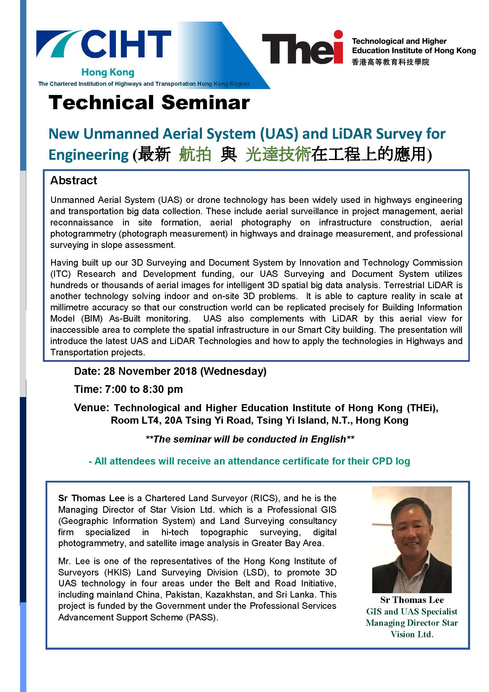
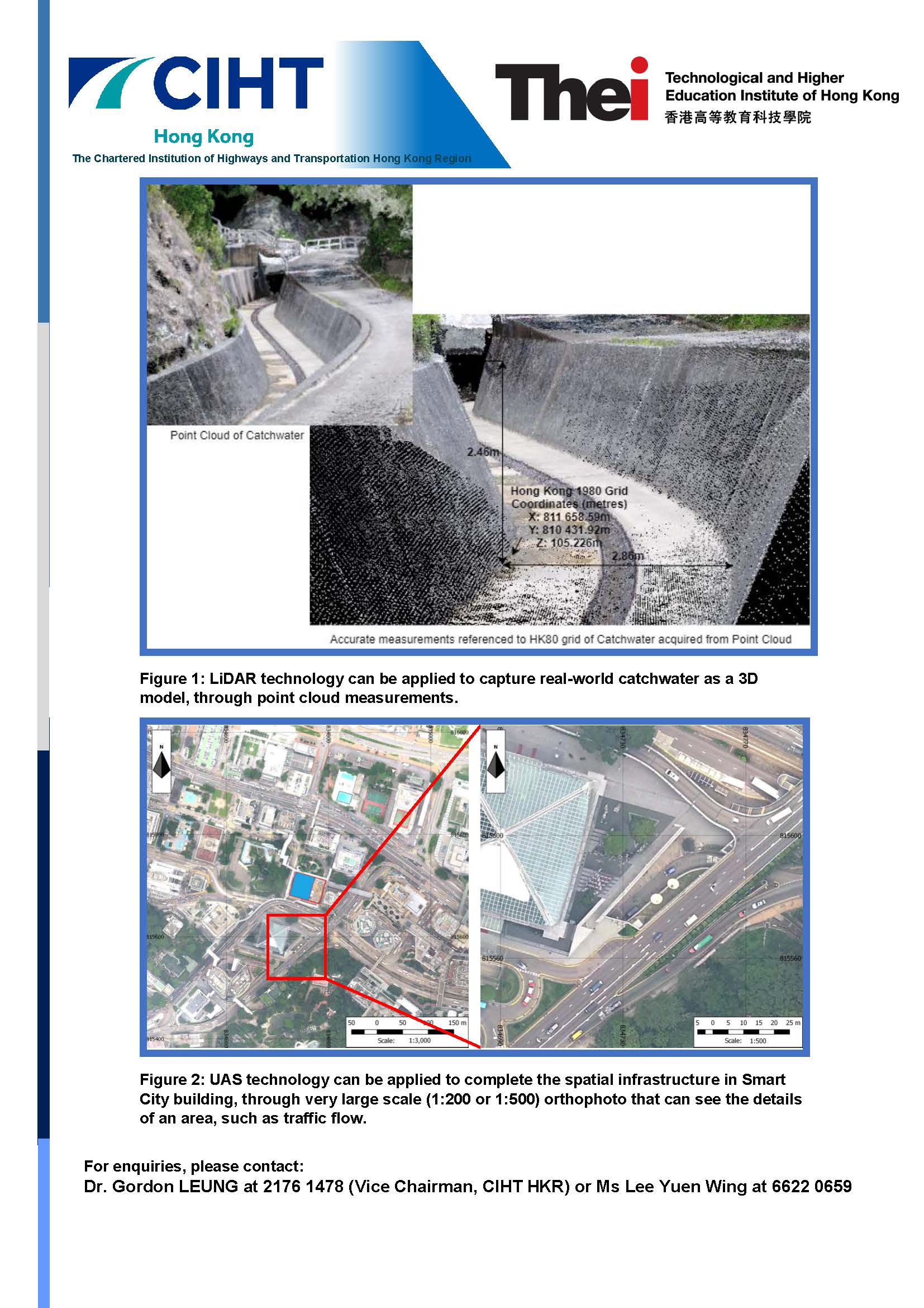
Having built up our 3D Surveying and Document System by Innovation and Technology Commission (ITC) Research and Development funding, our UAS Surveying and Document System utilizes hundreds or thousands of aerial images for intelligent 3D spatial big data analysis. Terrestrial LiDAR is another technology solving indoor and on-site 3D problems. It is able to capture reality in scale at millimetre accuracy so that our construction world can be replicated precisely for Building Information Model (BIM) As-Built monitoring. UAS also complements with LiDAR by this aerial view for inaccessible area to complete the spatial infrastructure in our Smart City building. The presentation will introduce the latest UAS and LiDAR Technologies and how to apply the technologies in Highways and Transportation projects.
|
Sr Thomas Lee is a Chartered Land Surveyor (RICS), and he is the Managing Director of Star Vision Ltd. which is a Professional GIS (Geographic Information System) and Land Surveying consultancy firm specialized in hi-tech topographic surveying, digital photogrammetry, and satellite image analysis in Greater Bay Area.
Mr. Lee is one of the representatives of the Hong Kong Institute of Surveyors (HKIS) Land Surveying Division (LSD), to promote 3D UAS technology in four areas under the Belt and Road Initiative, including mainland China, Pakistan, Kazakhstan, and Sri Lanka. This project is funded by the Government under the Professional Services Advancement Support Scheme (PASS). |
Sr Thomas Lee GIS and UAS Specialist Managing Director Star Vision Ltd. |

Figure 1: LiDAR technology can be applied to capture real-world catchwater as a 3D model, through point cloud measurements.

Figure 2: UAS technology can be applied to complete the spatial infrastructure in Smart City building, through very large scale (1:200 or 1:500) orthophoto that can see the details of an area, such as traffic flow.
For enquiries, please contact:
Dr. Gordon LEUNG at 2176 1478 (Vice Chairman, CIHT HKR) or Ms Lee Yuen Wing at 6622 0659


